


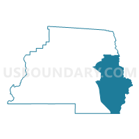
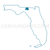
3-Voting District, Madison County, Florida
About
Outline

Summary
| Unique Area Identifier | 554900 |
| Name | 3-Voting District |
| County | Madison County |
| State | Florida |
| Area (square miles) | 127.25 |
| Land Area (square miles) | 126.70 |
| Water Area (square miles) | 0.55 |
| % of Land Area | 99.57 |
| % of Water Area | 0.43 |
| Latitude of the Internal Point | 30.39570390 |
| Longtitude of the Internal Point | -83.27622550 |
Maps

Graphs
Select a template below for downloading or customizing gragh for 3-Voting District, Madison County, Florida


Neighbors
Neighoring Voting District (by Name) Neighboring Voting District on the Map
- 1-Voting District, Lafayette County, FL
- 1-Voting District, Madison County, FL
- 10-Voting District, Madison County, FL
- 11-Voting District, Madison County, FL
- 7-Voting District, Hamilton County, FL
- 7-Voting District, Suwannee County, FL
- 8-Voting District, Hamilton County, FL
- 8-Voting District, Madison County, FL
- 8-Voting District, Suwannee County, FL
- 9-Voting District, Suwannee County, FL
Top 10 Neighboring County Subdivision (by Population) Neighboring County Subdivision on the Map
- Live Oak CCD, Suwannee County, FL (17,589)
- Madison CCD, Madison County, FL (15,625)
- Dowling Park CCD, Suwannee County, FL (7,987)
- Jennings CCD, Hamilton County, FL (4,835)
- Day CCD, Lafayette County, FL (3,164)
Top 10 Neighboring Place (by Population) Neighboring Place on the Map
Top 10 Neighboring Unified School District (by Population) Neighboring Unified School District on the Map
- Suwannee County School District, FL (41,551)
- Madison County School District, FL (19,224)
- Hamilton County School District, FL (14,799)
- Lafayette County School District, FL (8,870)
Top 10 Neighboring State Legislative District Lower Chamber (by Population) Neighboring State Legislative District Lower Chamber on the Map
Top 10 Neighboring State Legislative District Upper Chamber (by Population) Neighboring State Legislative District Upper Chamber on the Map
Top 10 Neighboring 111th Congressional District (by Population) Neighboring 111th Congressional District on the Map
Top 10 Neighboring Census Tract (by Population) Neighboring Census Tract on the Map
- Census Tract 1103.02, Madison County, FL (6,192)
- Census Tract 9703.02, Suwannee County, FL (6,184)
- Census Tract 9602, Hamilton County, FL (4,835)
- Census Tract 9702, Suwannee County, FL (4,363)
- Census Tract 1104, Madison County, FL (3,719)
- Census Tract 1101, Madison County, FL (3,235)
- Census Tract 9601, Lafayette County, FL (3,164)
- Census Tract 1103.01, Madison County, FL (2,479)
Top 10 Neighboring 5-Digit ZIP Code Tabulation Area (by Population) Neighboring 5-Digit ZIP Code Tabulation Area on the Map
- 32060, FL (21,363)
- 32340, FL (11,808)
- 32052, FL (9,223)
- 32066, FL (7,312)
- 32053, FL (3,869)
- 32059, FL (2,377)
- 32350, FL (1,417)